


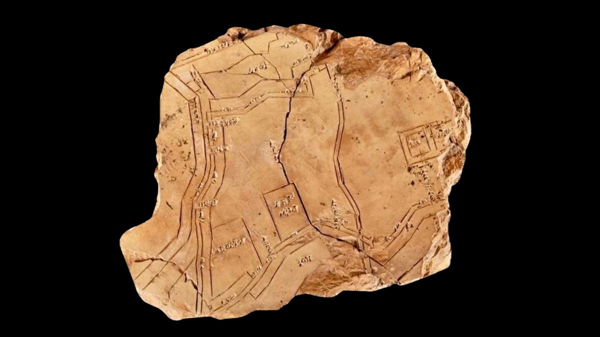
A clay tablet roughly the size of a hand, incised more than three thousand years ago, carries a plan of the Mesopotamian city of Nippur. It is the oldest known map of a city anywhere, and for most of the twentieth century nobody could agree on which way up it went.
It came out of the ground in 1899 and then sat in a drawer
Workers on the University of Pennsylvania’s excavation at Nippur, in what is now southern Iraq, turned it up in 1899. It measures about 21 by 18 centimetres and is a few centimetres thick. Hermann Volrath Hilprecht published a photograph in 1903, and the tablet has been in the Hilprecht Collection at Friedrich Schiller University in Jena ever since, catalogued as HS 197.
The surface was carefully prepared and the lines cut with a steady hand. Numerical measurements run along the walls in the sexagesimal system used throughout Mesopotamia, and place names appear in both Sumerian and Akkadian.
The cartographer left most of the city out
What the tablet records is the skeleton of Nippur in the second half of the second millennium BC. The city walls run in angular segments, pierced by seven gates, each with its name written beside it. Canals and moats frame the settlement. Inside the walls are the temple precinct of Ekur, dedicated to Enlil, the Ekiur associated with his consort Ninlil, a garden, and an enclosure whose function is not clear. The Euphrates appears to one side.
The residential quarters, which is to say most of the city, are largely absent. Attention goes to the defensive circuit, the watercourses and the sacred core, which tells you something about who the document was made for. Oelsner and Stein, who produced the standard edition in 2011, suggest the moat system was included for strategic rather than religious or administrative reasons.
Measurements along successive stretches of wall are given in the nindan, a unit of roughly six metres. Set against modern survey of the site, those figures resolve to a consistent scale of approximately one to nine thousand two hundred.
For seventy years it was read the wrong way round
When the map was properly published in 1905 it was taken to show only the eastern part of the city, and it was printed turned ninety degrees with the Ekur at the bottom. That orientation was chosen because it seemed to match the excavated remains as they were then understood. It did not match them well. Structures on the tablet sat awkwardly against what the trenches had produced, and the map picked up a reputation for being schematic or simply wrong.
Samuel Kramer argued in 1956 that it showed the entire city, and published it again in 1970 with Inez Bernhardt under a title calling it the oldest city map in the world. The question closed in the following decade. McGuire Gibson of the University of Chicago noticed on an aerial photograph that a ridge at the site appeared to coincide with a corner of the city wall as drawn on the tablet. His thirteenth season, in 1975, opened Area WC in the southernmost corner of the city and found fortifications where the clay said they would be. Miguel Civil, the expedition’s epigrapher, went back over the wall measurements and showed they only worked if the map covered the whole city and was oriented as Gibson proposed.
Nobody is certain how they did it
Mesopotamians were accomplished surveyors, and administrative tablets recording field boundaries and house plots survive in large numbers, drawn up for taxation and the management of land and water. The Nippur plan covers a far larger and more complicated area than any of them.
Augusta McMahon, professor of Mesopotamian archaeology at the University of Chicago and director of the school’s Nippur excavations, suggests knotted ropes, measuring rods, and possibly a rudimentary trigonometry for calculating angles. Whatever the method, it would have meant laborious incremental measurement over many days, then patient transfer onto clay.
It may be a plan rather than a record
Nippur had declined badly in the centuries before the tablet was made, and much of it stood abandoned. Then the Kassites took power in Babylonia and set about restoring the old religious center.
Johannes Hackl, professor of Assyriology at Jena, points to a Mesopotamian conception of kingship in which rulers held a duty to build. On that reading the tablet is not a picture of Nippur as it stood but a working document for its reconstruction, which would make it the earliest known urban blueprint as well as the oldest known city map. It is a proposal rather than a demonstration. Nothing on the tablet says what it was for.
Nothing else quite like it has survived
HS 197 remains unique. Smaller fragments of Mesopotamian city plans exist, but none combines topographic accuracy, detailed measurement and urban scale in the same way.
The tablet is still legible after three and a half thousand years. It records the walls and watercourses of a city, and beyond that a decision by particular people to measure the place their gods lived in, and set it down.
A note to readers. Ancient Content is written and researched independently, and paid subscribers are what keep it that way.
If these pieces are worth your time, consider subscribing. For a few dollars a month you get
A researched piece every day, checked against the primary sources
Short documentaries, and the full video archive
The complete written archive
Notes on what the coverage gets wrong, and why
Sources: National Geographic, December 2025 issue, "The Oldest Known Map of This Mesopotamian City Is Startlingly Precise." Institute for the Study of Ancient Cultures, University of Chicago, Nippur, Sacred City of Enlil, including McGuire Gibson on the Kassite map and Miguel Civil's reading of the wall measurements. Penn Museum, Expedition Magazine, Ancient Cartography. Hilprecht Collection, Friedrich Schiller University Jena.
The Ancients, in Mesopotamia, in southwestern North America, in the Indus Valley and in eastern China, seem to have had a far better grasp of just how fragile the environment was, and therefore how important it was to get their infrastructure done properly.
“A duty to build”. Fascinating. Not preserving the status quo but always moving onward.